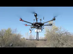
Land Surveying Vtol LiDAR Long Detection Geosun gAirHawk GS-2000N
Quality UAV LiDAR System from China.
https://www.geosunlidar.com/china-land_surveying_vtol_lidar_long_detection_geosun_gairhawk_gs_2000n-34537549.html
Wuhan Geosun Navigation Technology Co., Ltd quality manufacturer from China.
We can supply:
LiDAR Scanning System : https://www.geosunlidar.com/supplier-lidar_scanning_system-432797.html
UAV LiDAR System : https://www.geosunlidar.com/supplier-uav_lidar_system-434782.html
Mobile LiDAR System : https://www.geosunlidar.com/supplier-mobile_lidar_system-434783.html
Welcome to visit our official website : http://www.geosunlidar.com
UAV LiDAR System
-

Land Surveying Vtol LiDAR Long Detection Geosun gAirHawk GS-2000N
Contact Now -
High Accuracy UAV LiDAR System with Wide Field of View
Contact Now -
Long Range Laser Scanning VTOL UAV Vehicle Supported Five Echo Colored Point Cloud Free Trajectory Processing
Contact Now -
Terrain Mapping Aerial Surveying Geosun UAV LiDAR System GS-130X High Precision
Contact Now -
University Cooperation LiDAR Drone Scanner Geosun GS-100C+ High Precision IMU Colour
Contact Now
Related Videos


Check out the GS-1500N demonstration at the State Grid Substation
Drone Mapping Solution
April 16, 2024


GS-260X LiDAR Scanning System Application for Power Line Patrol
Mobile Mapping Solution
June 03, 2021