Check out the GS-1500N demonstration at the State Grid Substation
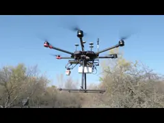
GS-1500N is applied for State Grid Substation. The detailed of the substation, such as network ground wire and insulator structure can be scanned clearly and continuousouly at 200/300m altitude. The 10kv distribution network lines are also completely restored.
geosun
Long Range LiDAR solution
Power Line application
GS-1500N
3D data
-

GAirHawk Series GS-1500N LiDAR Scanning System 8 Echos Long Detection Aerial VTOL Mapping
Contact Now -
Multi Rotor LiDAR Drone For Inspection Mapping Surveying Security
Contact Now -
High Accuracy UAV LiDAR System with Wide Field of View
Contact Now -
Long Range 1000M Flight Altitude 1cm Accuracy Mobile LiDAR Geosun GS-1350W
Contact Now -
Long Range Laser Scanning VTOL UAV Vehicle Supported Five Echo Colored Point Cloud Free Trajectory Processing
Contact Now
Related Videos


Land Surveying Vtol LiDAR Long Detection Geosun gAirHawk GS-2000N
Drone Mapping Solution
May 30, 2023


GS-260X LiDAR Scanning System Application for Power Line Patrol
Mobile Mapping Solution
June 03, 2021