UAV lidar GS-100C+
UAV Lidar collects geographic information and is used in agriculture, forestry, minerals, rivers and lakes.
www.geosunlidar.com
www.geosunlidar.com
LiDAR
UAV LiDAR
-

DJI Drone Mount LiDAR Scanning System With Livox Avia Laser Sensor
Contact Now -
High Accuracy UAV LiDAR System with Wide Field of View
Contact Now -
Long Range Laser Scanning VTOL UAV Vehicle Supported Five Echo Colored Point Cloud Free Trajectory Processing
Contact Now -
Terrain Mapping Aerial Surveying Geosun UAV LiDAR System GS-130X High Precision
Contact Now -
University Cooperation LiDAR Drone Scanner Geosun GS-100C+ High Precision IMU Colour
Contact Now
Related Videos

LiDAR Device for Drone and Vehicle Detailed Look
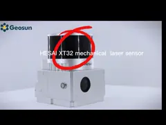
LiDAR Scanning System Presentation
September 26, 2022