Chat Now
Contact Us
Home
videos
Playlist
About us
Official Web
English
English
French
German
Italian
Russian
Spanish
Portuguese
Dutch
Greek
Japanese
Korean
Arabic
Hindi
Turkish
Indonesian
Vietnamese
Thai
Bengali
Persian
Polish
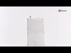
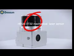
UAV Lidar GS-100C with pylon video
LiDAR Scanning System Presentation
June 22, 2021
Chat Now
UAV Lidar collects geographic information and is used in agriculture, forestry, minerals, rivers and lakes.
www.geosunlidar.com
UAV Lidar
mapping
instrument
GAirHawk Series GS-1500N LiDAR Scanning System 8 Echos Long Detection Aerial VTOL Mapping
Contact Now
Multi Rotor LiDAR Drone For Inspection Mapping Surveying Security
Contact Now
High Accuracy UAV LiDAR System with Wide Field of View
Contact Now
Long Range 1000M Flight Altitude 1cm Accuracy Mobile LiDAR Geosun GS-1350W
Contact Now
Long Range Laser Scanning VTOL UAV Vehicle Supported Five Echo Colored Point Cloud Free Trajectory Processing
Contact Now
Related Videos
00:28
LiDAR Device for Drone and Vehicle Detailed Look
LiDAR Scanning System Presentation
September 26, 2022
00:17
UAV lidar GS-100C+
LiDAR Scanning System Presentation
November 09, 2021
00:29
UAV lidar GS-130H
LiDAR Scanning System Presentation
July 26, 2021
04:06
Automatic Point Cloud Classification Tool
Other Videos
March 17, 2023
00:30
Application of Mobile LiDAR Mapping in Road
Other Videos
April 13, 2023
00:59
GEO WEEK 2024
Other Videos
March 04, 2024
00:16
UAV Lidar GS-100M is suitable for other types of aircraft
Drone Mapping Solution
June 24, 2021
00:44
UAV Lidar GS-260F with DJ M600 UAV
Drone Mapping Solution
June 25, 2021
00:16
UAV lidar GS-1350W
Drone Mapping Solution
July 26, 2021
01:14
UAV lidar GS-100M
Drone Mapping Solution
August 04, 2021