


Geosun gAirHawk Series GS-100V LiDAR Scanning System HESAI XT16 Laser Sensor Built-In Camera High Precision Aerial Scan

Contact Person : Lanbooxie
Phone Number : +86 15527360208
WhatsApp : +8615527360208

| Minimum Order Quantity : | 1 | Price : | Negotiation |
|---|---|---|---|
| Packaging Details : | Suit Case 450*365*200 mm | Delivery Time : | 10-15 works days |
| Payment Terms : | L/C, T/T | Supply Ability : | 80 SETS/Month |
| Place of Origin: | China | Brand Name: | Geosun |
|---|---|---|---|
| Certification: | CE,ISO | Model Number: | GS-260F |
|
Detail Information |
|||
| Material: | Aluminum Alloy Body | Accuracy: | 10cm@150m |
|---|---|---|---|
| Dimension: | 18.6*10.9*12cm | Storage: | 64GB Max Support 128GB TF Card |
| Working Temperature: | -20°~+55° | Carrying Platform: | Multi-Rotor/VTOL |
| Channel: | 40 Channel | Application: | Forestry, Power Line Patrol, Historical Relics |
| High Light: | GS-260F LiDAR Scanning System,LiDAR Scanning System HESAI Pandar 40P,RTK Model uav lidar scanner |
||
Product Description
GS-260F LiDAR Scanning System HESAI Pandar 40P Versatile Application RTK Model Power Line
Geosun gAirHawk Series GS-260F LiDAR Scanning System
GS-260F LiDAR scanning system is an UAV measurement system independently developed by Geosun company. It highly integrates laser scanner, GNSS satellite positioning system, INS inertial navigation system and camera(built-in), and can quickly obtain high-precision laser point cloud number. It can be widely used in Power line,Digital city construction, Industry, Land survey, Forestry and Agriculture.
Specification of LiDAR Scanning System gAirHawk GS-260F
|
LiDAR Scanning System gAirHawk GS-260F |
||
|
|
Item Name |
System Parameters |
|
Parameters |
Weight |
2.1 kg |
|
Measuring accuracy |
Less than 0.1m @150m |
|
|
Working temperature |
-20℃~+65℃ |
|
|
Power range |
12 V- 24 V |
|
|
Consumption |
10 W |
|
|
Carrying Platform |
DJI M300, M600, GS-800, GS-850....... |
|
|
Storage |
64 GB storage, maximum support 128GB TF card |
|
|
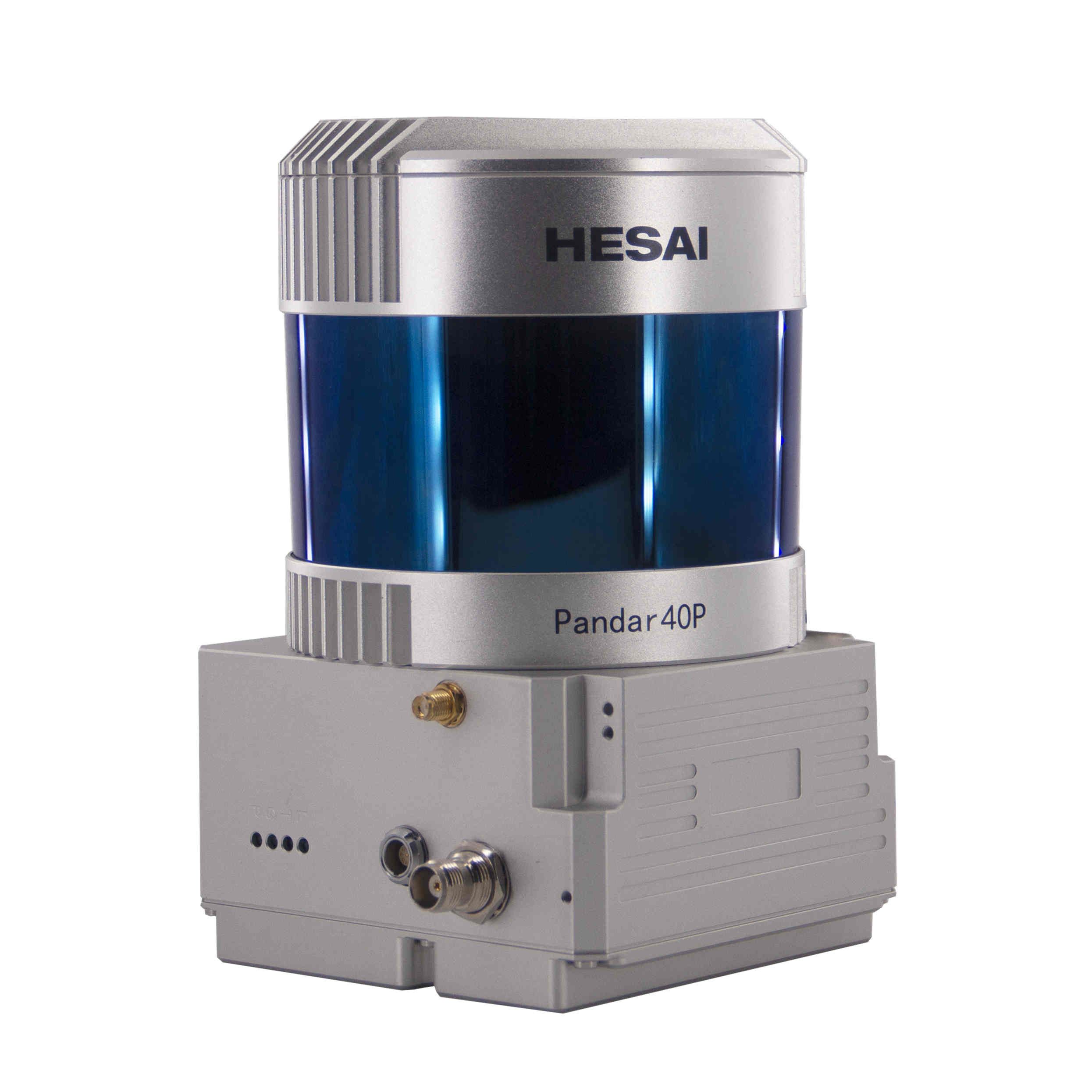
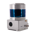
Lidar Unit
|
Measuring Range |
230m@10% Reflectivity |
|
Laser class |
905nm Class1 (IEC 60825-1:2014) |
|
|
Channel |
40-Channel |
|
|
Range accuracy |
±2cm (typical Value) | |
|
Scanning frequency |
10HZ, 20HZ |
|
|
Data |
Double echo 720,000 Points/Sec |
|
|
FOV |
360°, adjustable |
|
|
Laser sensor |
HESAI Pandar40P |
|
|
POS Unit |
Update frequency |
200HZ |
|
Heading accuracy |
0.017° |
|
|
Pitch accuracy |
0.005° |
|
|
Rolling accuracy |
0.005° |
|
|
Position accuracy |
≤0.05m |
|
|
GNSS signal type |
GPSL1/L2/L5 GLONASSL1/L2, BDS B1c/ B1/B2/B2a/B3 GAL E1/E5a/5b |
|
|
Pre-processing software |
POS software |
Output information: position, speed, attitude |
|
Point cloud software |
Output point cloud data format: LAS format, custom TXT format |
|
|
Camera (built-in) |
Effective Pixel |
26 Mega Pixels |
|
Focal Length(mm) |
16 |
|
| FOV | 86-Degree | |
Applications LiDAR scanning system GS-260F (RTK Model)
![]()
![]()
![]()
Free Trial Software UAV LiDAR Scanning System gAirHawk GS-260F
Free trial test, achieve high precision
The Guideline of LiDAR Usage and Reference.pdf
Point Cloud Pre-Processing Software Integrated With Trajectory Processing----Geosun Self-developed gAirHawk 5.0
Key Features of gAirHawk 5.0 Software
1. Raw data: intelligently load
2. Four default coordinates
3. Point cloud Optimization
4. Start and stop calculation
![]()
![]()
Package LiDAR Scanning System gAirHawk GS-260F
LiDAR Scanning System gAirHawk GS-260F is packed by suit case with EVA material liner inside, then covered by hard carton box. It is suitable for air shipment and sea shipment.
![]()
![]()
Enter Your Message
| Wuhan Geosun Navigation Technology Co., Ltd |
| 4F, Building D, Tianyi plaza No.8 West Maodianshan Road, East Lake Hi-tech Zone Wuhan City, China |
| +86--15527360208 |
| sales@geosunlidar.com |