


Geosun gAirHawk Series GS-100V LiDAR Scanning System HESAI XT16 Laser Sensor Built-In Camera High Precision Aerial Scan

Contact Person : Lanbooxie
Phone Number : +86 15527360208
WhatsApp : +8615527360208

| Minimum Order Quantity : | 1 | Price : | Negotiation |
|---|---|---|---|
| Packaging Details : | Suit Case 450*365*200 mm | Delivery Time : | 7-10 Working Days |
| Payment Terms : | T/T, Western Union | Supply Ability : | 80 Sets/Month |
| Place of Origin: | China | Brand Name: | Geosun |
|---|---|---|---|
| Certification: | CE, ISO | Model Number: | GS-100C |
|
Detail Information |
|||
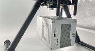
| Compatibility: | DJI M300 RTK | Application: | 3D Data Mapping |
|---|---|---|---|
| High Density: | 720,000 Points/s, Triple-echo | Light Weight: | 1022g |
| Dimension: | 13.8*9.1*9.4cm | Accuracy: | 10cm@100m |
| Working Temperature: | -20°~+55° | Storage: | 64GB Max Support 128GB TF Card |
| Pre-Processing Software: | Shuttle&gAirHawk | ||
Product Description
GS-100C LiDAR Scanning System Skyport DJI M300 Livox Avia Sensor Colored Point Cloud
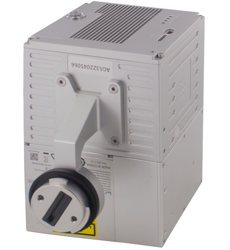
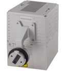
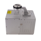
Geosun gAirHawk GS-100C LiDAR Scanning System
gAirHawk GS-100C is a kind of light compact LiDAR point cloud data acquisition system, integrated Livox new generation laser scanner, GNSS and IMU positioning and attitude determination system, and storage control unit, is able to real-time, dynamically, massively collect high-precision point cloud data and rich image information. It is widely used in the acquisition of 3D spatial information in surveying, electricity, forestry, agriculture, land planning.
Applications of LiDAR Scanning System GS-100C
LiDAR Scanning System GS-100C also has strong penetration in the face of dense forests, and deep integration greatly saves operational efficiency.
![]()
![]()
![]()
![]()
![]()
![]()
Specification of LiDAR Scanning System GS-100C
|
LiDAR Scanning System gAirHawk GS-100C |
||
|
|
Item Name |
System Parameter |
|
Parameter |
Weight |
1070 G |
|
Measuring accuracy |
Less than 15 cm (100 m AGL) |
|
|
Power range |
12V~16V |
|
|
Working temperature |
-20℃~+55℃ |
|
|
Consumption |
Average 20W |
|
|
Support Platform |
DJI M300 RTK (RTK mode) |
|
|
Storage |
64GB storage, maximum support 128GB TF card |
|
|
Lidar Unit
|
Laser Model |
Livox Avia |
|
Measuring Range |
190m@10% Reflectivity |
|
|
Laser class |
905nm Class1 (IEC 60825-1:2014) |
|
|
Laser line number |
Equivalent to 64-beam |
|
|
Range Precision |
2 cm |
|
|
data |
Triple-echo, 720,000 Points/Sec |
|
|
FOV |
70° the circular view |
|
|
POS Unit |
POS type |
AGS 302 |
|
Update frequency |
200HZ |
|
|
Heading accuracy |
0.080° |
|
|
Pitch accuracy |
0.025° |
|
|
Rolling accuracy |
0.025° |
|
|
Position accuracy |
0.02 - 0.05m |
|
|
GNSS signal type |
GPSL1/L2/L5 GLONASSL1/L2 BDS B1/B2/B3 GAL E1/E5a/5b |
|
|
Pre-processing software |
POS software |
Output information: position, speed, attitude |
|
Point cloud software |
Output point cloud data format: LAS format, custom TXT format |
|
|
Build-in Camera |
FOV |
83 Degree |
|
Effective Pixel |
26 Mega Pixel |
|
|
Trigger event |
Distance or Time trigger |
|
Free Trial Software LiDAR Scanning System gAirHawk GS-100C
Free trial test, achieve high precision
The Guideline of LiDAR Usage and Reference.pdf
Point Cloud Pre-Processing Software Integrated With Trajectory Processing----Geosun Self-developed gAirHawk 5.0
Key Features of gAirHawk 5.0 Software
1. Raw data: intelligently load
2. Four default coordinates
3. Point cloud Optimization
4. Start and stop calculation
![]()
![]()
Package of LiDAR Scanning System GS-100C
LiDAR Scanning System GS-100C packed by suit case with EVA material liner inside, then covered by hard carton box. It is suitable for air shipment and sea shipment.
![]()
![]()
Enter Your Message
| Wuhan Geosun Navigation Technology Co., Ltd |
| 4F, Building D, Tianyi plaza No.8 West Maodianshan Road, East Lake Hi-tech Zone Wuhan City, China |
| +86--15527360208 |
| sales@geosunlidar.com |