

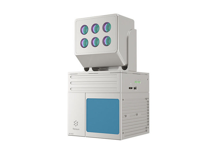
EU Airborne UAV LiDAR Scanning GS-130X Hesai XT32 Laser Senor High Accuracy Pos Colored Point Cloud

Contact Person : Lanbooxie
Phone Number : +86 15527360208
WhatsApp : +8615527360208

| Minimum Order Quantity : | 1 | Price : | Negotiation |
|---|---|---|---|
| Packaging Details : | Suit Case 520*420*230 mm | Delivery Time : | 10-15 works days |
| Payment Terms : | T/T, Western Union | Supply Ability : | 30 SETS/Month |
| Place of Origin: | China | Brand Name: | Geosun |
|---|---|---|---|
| Certification: | CE, ISO | Model Number: | GS-100D+Multispectral Camera LiDAR System |
|
Detail Information |
|||
| Operation Efficiency: | 0.88 Km2 / Single Flight | Application: | Forestry |
|---|---|---|---|
| Compatibility: | Multi Rotor/ VTOL | Appliation: | Agriculture |
| Feature: | RGB & NDVI | Material: | Aluminum Alloy Body |
| High Light: | 0.88 Km2 UAV Lidar Systems,Multispectral Camera UAV Lidar Systems,Laser Sensor UAV Lidar Systems |
||
Product Description
gAirHawk GS-100D+Multispectral Camera LIDAR SCANNING SYSTEM
LiDAR Scanning System with Livox Avia Laser Sensor Mounted on GS-800 Multi Rotor Drone
Specification
|
|||||||||||||||||||||||||||||||||||||||||||||||||||||||||||||
Application for Forestry & Agriculture
![]()
Package
It is packed by suit case with EVA material liner inside, then covered by hard carton box. It is suitable for air shipment and sea shipment.
![]()
Enter Your Message
| Wuhan Geosun Navigation Technology Co., Ltd |
| 4F, Building D, Tianyi plaza No.8 West Maodianshan Road, East Lake Hi-tech Zone Wuhan City, China |
| +86--15527360208 |
| sales@geosunlidar.com |