


Long Range 1000M Flight Altitude 1cm Accuracy Mobile LiDAR Geosun GS-1350W

Contact Person : Lanbooxie
Phone Number : +86 15527360208
WhatsApp : +8615527360208

| Minimum Order Quantity : | 1 | Price : | Negotiation |
|---|---|---|---|
| Packaging Details : | Suit Case 450*365*200 mm | Delivery Time : | 5-7 works days |
| Payment Terms : | T/T, Western Union | Supply Ability : | 30 SETS/Month |
| Place of Origin: | China | Brand Name: | Geosun |
|---|---|---|---|
| Certification: | CE, ISO | Model Number: | GS-100V LiDAR Scanning System |
|
Detail Information |
|||
| Operation Efficiency: | 0.96 Km2 / Single Flight | Application: | Vehicle Mapping & Survey |
|---|---|---|---|
| Accuracy: | Less Than 10 Cm | FOV: | 360 Degree |
| High Light: | 15W 128GB HESAI Laser LiDAR,128GB TF Card Short Range LiDAR,Geosun 15W Short Range LiDAR |
||
Product Description
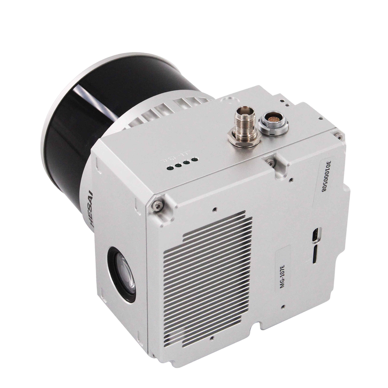
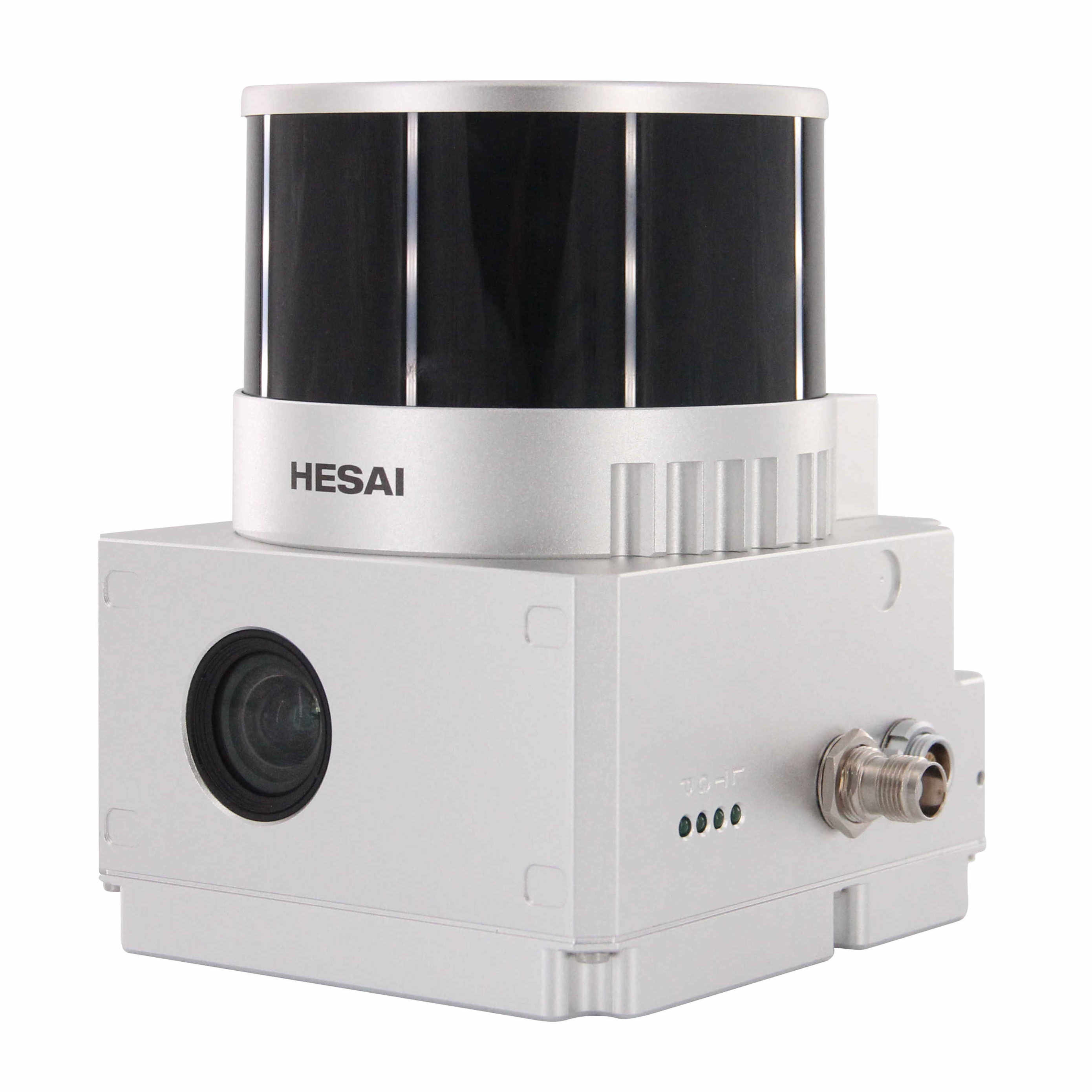
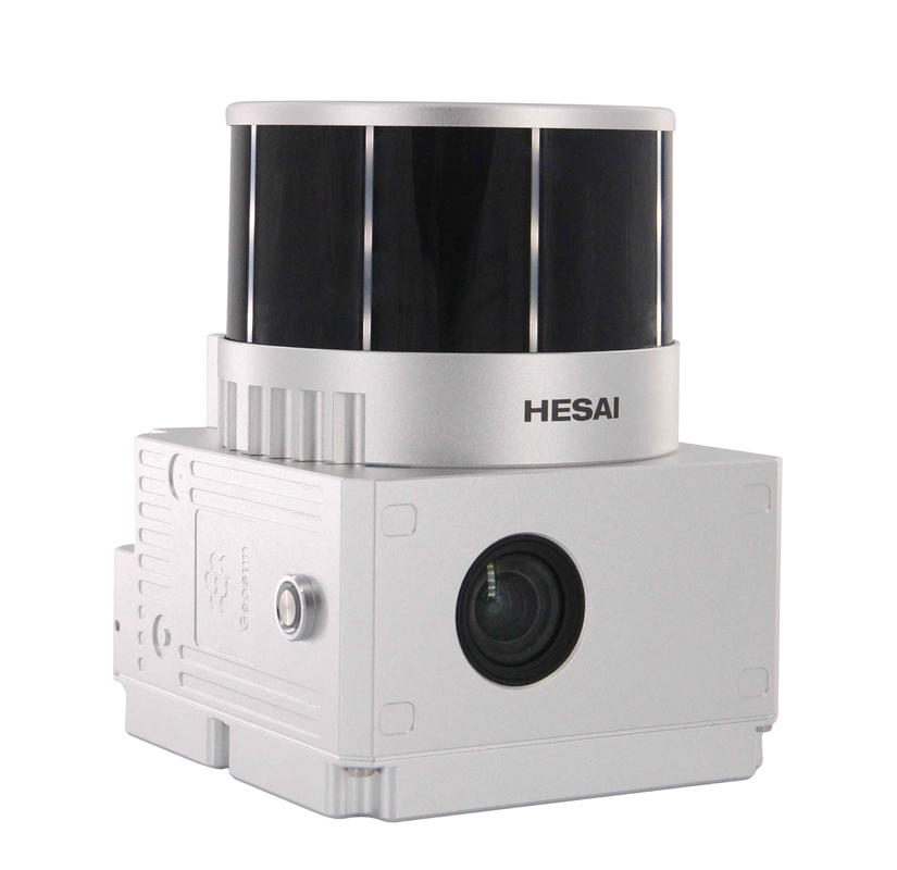
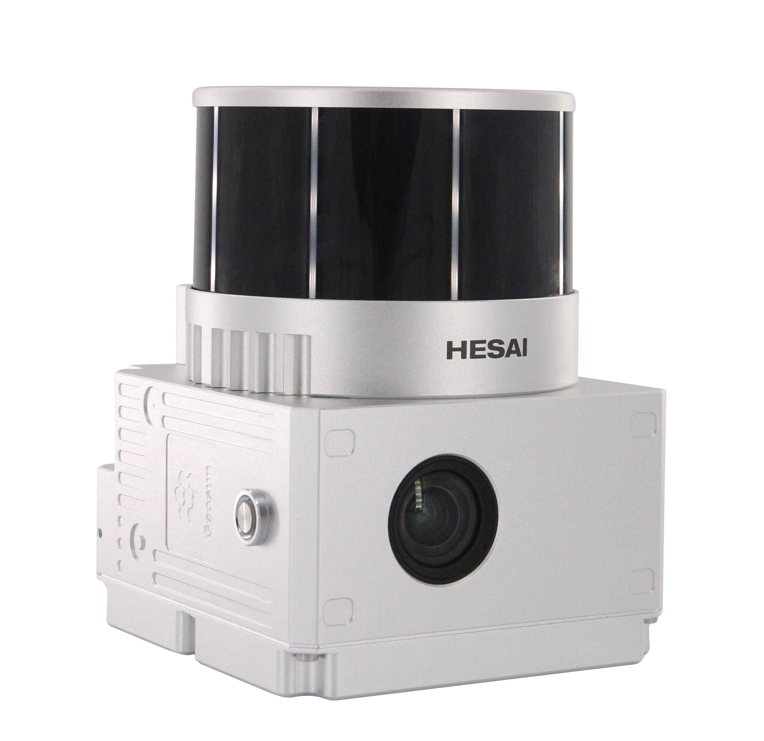
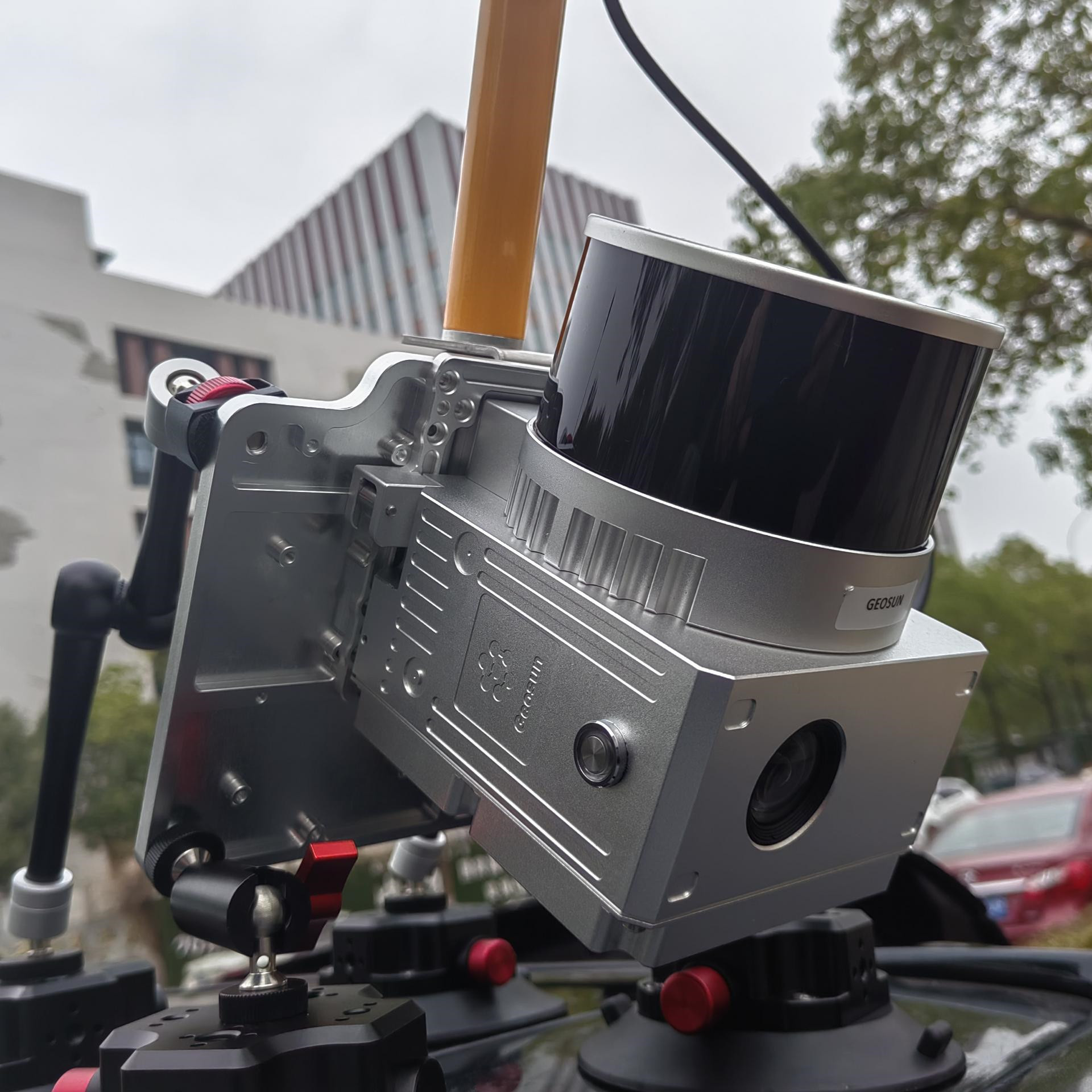
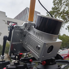
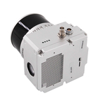
HESAI Laser Sensor Short Range LiDAR Mobile Mapping Geosun GS-100V
Geosun gAirHawk Series GS-100V Mobile LiDAR Scanning System
gAirHawk GS-100V is a kind of short range, compact LiDAR point cloud data acquisition system, integrated HESAI XT 16 Channel laser scanner, GNSS and IMU positioning and attitude determination system, and storage control unit, is able to real-time, dynamically, massively collect high-precision point cloud data and rich image information. It is widely used in the acquisition of 3D spatial information in surveying, electricity, forestry, agriculture, land planning.
Specficaiton of Geosun gAirHawk Series GS-100V Mobile LiDAR Scanning System
|
gAirHawk GS-100V Mobile LiDAR Scanning System |
||
|
|
Item Name |
System Parameters |
|
Parameters |
Weight |
1.26 kg |
|
Measuring accuracy |
Less than 0.1m @120m |
|
|
Working temperature |
-20℃~+65℃ |
|
|
Power range |
12 V- 24 V |
|
|
Consumption |
10W |
|
|
Carrying Platform |
Vehicle and Drone |
|
|
Storage |
64 GB storage, maximum support 128GB TF card |
|
|
Lidar Unit
|
Measuring Range |
0.3m-120m@10% Reflectivity |
|
Laser class |
905nm Class1 (IEC 60825-1:2014) |
|
|
Channel |
16-Channel |
|
|
Range accuracy |
±1cm (typical Value) |
|
|
Scanning frequency |
10HZ, 20HZ |
|
|
data |
Double echo 640,000 Points/Sec |
|
|
FOV |
360°, adjustable |
|
|
Laser sensor |
HESAI Pandar XT |
|
|
POS Unit |
Update frequency |
200HZ |
|
Heading accuracy |
0.040° |
|
|
Pitch accuracy |
0.015° |
|
|
Rolling accuracy |
0.015° |
|
|
Position accuracy |
≤0.05m |
|
|
GNSS signal type |
GPSL1/L2/L5 GLONASSL1/L2 BDS B1/B2/B3 GAL E1/E5a/5b |
|
|
Pre-processing software |
POS software |
Output information: position, speed, attitude |
|
Point cloud software |
Output point cloud data format: LAS format, custom TXT format |
|
|
Camera (built-in) |
FOV |
83 degree |
|
Effective Pixel |
26 Mega Pixel |
|
| Focal length(mm) | 16 | |
Application of Geosun gAirHawk Series GS-100V Mobile LiDAR Scanning System
![]()
Free Trial Software LiDAR Scanning System gAirHawk GS-130X
Free trial test, achieve high precision
The Guideline of LiDAR Usage and Reference.pdf
Point Cloud Pre-Processing Software Integrated With Trajectory Processing----Geosun Self-developed gAirHawk 5.0
Key Features of gAirHawk 5.0 Software
1. Raw data: intelligently load
2. Four default coordinates
3. Point cloud Optimization
4. Start and stop calculation
![]()
![]()
Package of Geosun gAirHawk Series GS-100V Mobile LiDAR Scanning System
Geosun gAirHawk Series GS-100V Mobile LiDAR Scanning System is packed by suit case with EVA material liner inside, then covered by hard carton box. It is suitable for air shipment and sea shipment.
![]()
![]()
Enter Your Message
| Wuhan Geosun Navigation Technology Co., Ltd |
| 4F, Building D, Tianyi plaza No.8 West Maodianshan Road, East Lake Hi-tech Zone Wuhan City, China |
| +86--15527360208 |
| sales@geosunlidar.com |