

IMU Module GNSS INS Hardware Integration Velocity Measurement

Contact Person : Lanbooxie
Phone Number : +86 15527360208
WhatsApp : +8615527360208


| Minimum Order Quantity : | 1 | Price : | Negotiation |
|---|---|---|---|
| Packaging Details : | Hard Carton 230*160*100 mm | Delivery Time : | 5-10 Working Days Since Payment |
| Payment Terms : | T/T, Western Union, L/C | Supply Ability : | 30 SETS/Month |
| Place of Origin: | China | Brand Name: | Geosun |
|---|---|---|---|
| Certification: | CE, ISO | Model Number: | AGS 300 Aerial GNSS Receiver |
|
Detail Information |
|||
| Name: | GNSS INS System | Application 1: | Positioning And Altitude |
|---|---|---|---|
| Application 2: | Velocity Measurement | Function: | 3D Data Collector |
| Tracking Signal: | GPS BDS GLONASS | Processor: | 180 MHz ARM 9 Industrial Processor |
| High Light: | GLONASS GNSS INS System,BDS GNSS INS System,GPS GNSS INS System |
||
Product Description
GPS BDS GLONASS GNSS INS System For Positioning And Altitude
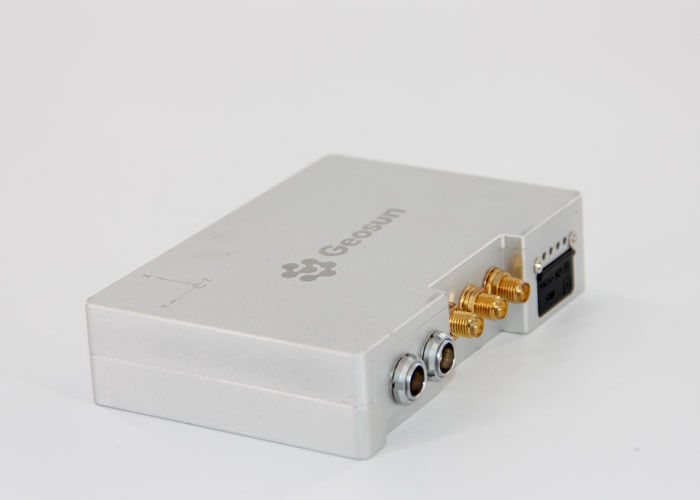
AGS 300 GNSS INS System adds a high-precision inertial navigation (IMU) module, no matter how the fuselage tilts during the aviation flight, it can accurately provide position, velocity and 3D attitude information.
After the data processing of professional software, AGS 300 provides threedimensional position accuracy of 0.05 m, velocity of 0.02 m/s, heading of 0.080 degree, and pitch/roll of 0.030 degree, data sampling rate ups to 200Hz. With AGS 300, UAV Aerial remote sensing can completely be free from ground control point, it is especially applied to the UAV surveying in strip area, irregular shape area, large watershed area and high latitude area; and is also widely used in UAV laser scanning and other direct geo-reference aerial remote sensing fields. For the users who required high-precision and real-time in precision agriculture, electricity and other areas, AGS 300 also offers GNSS real-time differential positioning (RTK) function.
Specification
| Tracking Signal | GPS: L1 C/A code, L2 C, L1 / L2 ; |
| BDS : B1, B2a, B3 | |
| GLONASS: L1 C/A and P code, L1 /L2 , L2 P code | |
| Processor | Processor : 180 MHz ARM 9 industrial processor |
| Build-in Ram | Build-in RAM : 2 x 64 MB SDRAM |
| Build-in Flash | Build-in flash : 4 MB data flash; 1 GB nand flash |
| SD Card Storage | Standard 8 G micro SD card, max support up to 32 GB |
| Updated rate | Default update rate 5 Hz, max update rate 50 Hz |
| Storage format | Rinex, Binex |
| Indicator | 4 LED indicators, same function, indicate GNSS signal and power, 3G connection indicator |
| and antenna working indicator | |
| PW/EVEN/PPS/RS232 | One lemon 9 pin interface, one lemon 6 pin double interface |
| Antenna interface | One external antenna interface, one UHF antenna interface, one 3G antenna interface |
| Mini usb interface | One mini USB port |
| Micro SD card slot | One micro SD card slot |
| Micro SIM card slot | SIM card slot |
| Dimension (mm) | 125*85*34 |
| Weight (g) | 120 , 210 with Cover |
| Voltage (v) | 8-26 |
| Power consumption (w) | 3.3 |
| Working temperature | - 20 ℃-- 60 ℃ |
| Storage temperature | - 40℃-- 80 ℃ |
| Pitch & Rolling | 0.025 deg |
| Heading | 0.08 deg |
| Speed | 0.02 m/s |
| Positioning Accuracy | 2-5 cm |
Application for Photography
![]()
![]()
Application for POS Data Post Processing
![]()
![]()
![]()
Enter Your Message
| Wuhan Geosun Navigation Technology Co., Ltd |
| 4F, Building D, Tianyi plaza No.8 West Maodianshan Road, East Lake Hi-tech Zone Wuhan City, China |
| +86--15527360208 |
| sales@geosunlidar.com |